Hiking tour among lakes and glaciers in the Ortler-Cevedale
- Discover with this hiking tour the exceptional landscape variety of Ortler Cevedale, walking in one of the biggest European nature reserves
- Reach the exclusive panoramic points that amaze you with breathtaking views of more than 3500 meters high summits
- Enjoy the traditional hospitality of family-run alpine huts in one the best hiking tour on the Alps
PROGRAM
Hiking traverse among lakes and glaciers in the Ortler-Cevedale - in the heart of Stelvio National Park
The Stelvio National Park is the largest protected area in Italy and one of the oldest. Established in 1935, it safeguards the extraordinary landscapes and rich biodiversity of the majestic Ortles‑Cevedale mountain range. Known as the land of lakes and glaciers, the park offers visitors spectacular alpine scenery and enchanting natural settings.
This tour leads you into the heart of pristine nature, following trails that wind through constantly changing alpine landscapes. From the meadows and pastures of Val di Rabbi - characterised by traditional mountain huts and alpine farms that preserve ancient customs and authentic flavours - the itinerary ascends toward the reddish rock formations that frame the mountain huts. Every step reveals a new chapter in the story of these mountains and brings you deeper into the heart of the park. Along the way, you encounter the foaming Saent waterfalls before reaching the higher altitudes, where perennial snowfields reflect the peaks around them, and eventually the crystal‑clear lakes of the Cevedale area. The tour culminates at the vast and solitary Careser Glacier, where the mountains reveal their full magnificence. From here, the view opens onto the most celebrated summits of the Ortles‑Cevedale range, extending all the way to the peaks of the Adamello and the Brenta Dolomites.
You can look forward to intense hiking days through some of the most beautiful valleys of the Stelvio National Park: Val di Rabbi with its waterfalls and flowered meadows, Val di Peio with its high‑altitude pastures, and Val Martello framed by imposing peaks. After each day of hiking, you’can enjoy the warmth and hospitality of welcoming alpine huts - places where you can unwind and experience the convivial spirit of the mountains.
Short on time? No problem! The itinerary has different route options and is also available in three‑, four‑ or five‑day versions, allowing you to choose the pace that best suits your trip.
With Campo Base, you have all the organisation and support you need - both before and during your journey - to enjoy this experience in total freedom and safety. Get ready to discover one of the largest natural parks in Europe, in an adventure you won’t forget.
Program details - 8 Day Tour:
- Day 1
Arrival in Val di Sole and check-in in 3* hotel.
- Day 2 - LAKES CORVO
Ascent: +1020m. Descent: -0m. Altitude: 1420 - 2430m. Distance: 5km. Hiking time: 4h.
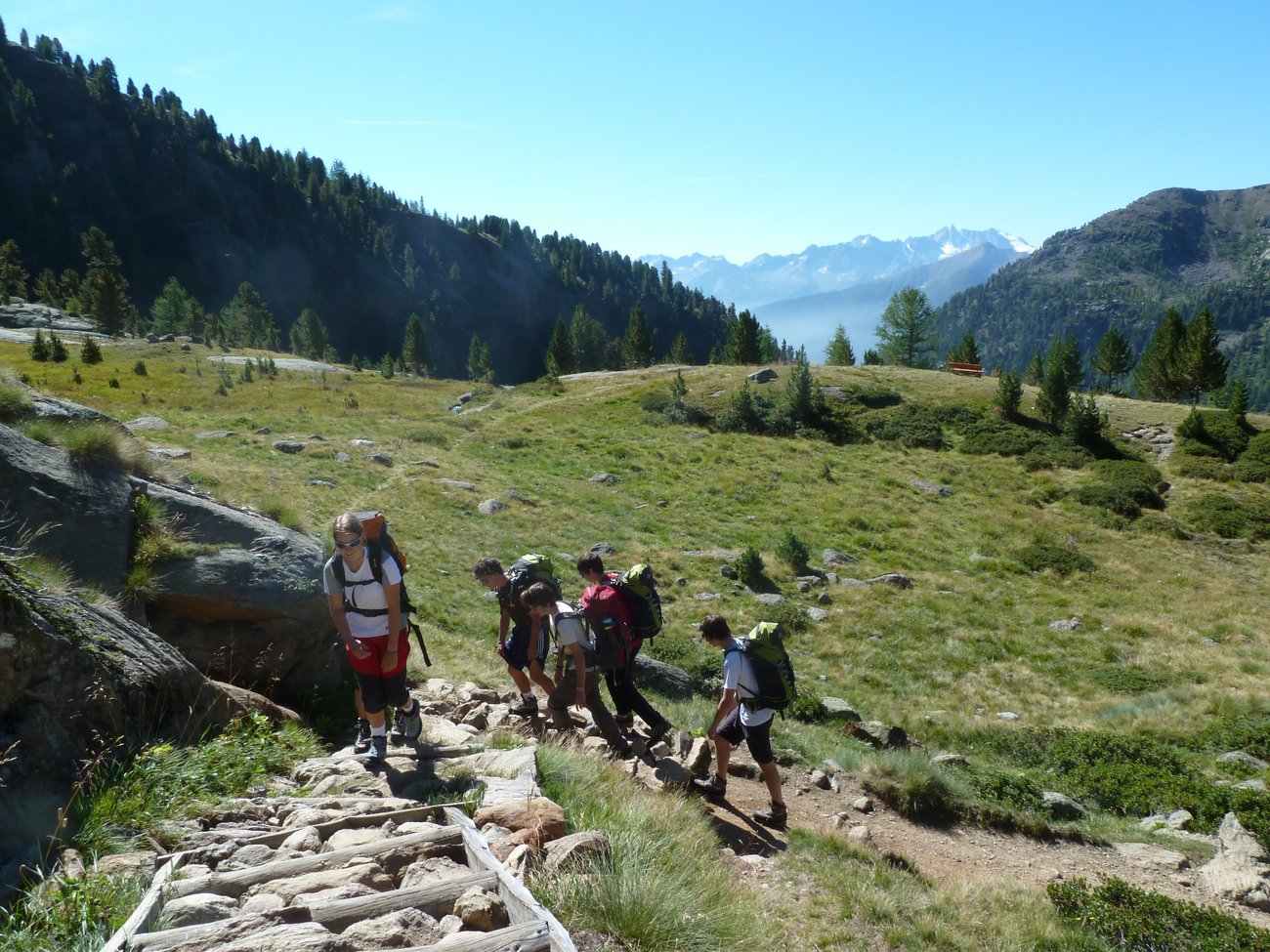
In the morning, you reach the trailhead in Val di Rabbi. Across forests of larches and firs, the trail leads you to some alpine huts, where the farmers milk their cattles and produce Casolet, the local cheese. Above the tree-line, you keep walking across wide mountain grasslands and, through a steadily uphill trail, you reach the slopes of Quaira peak, the highest peak of Maddalene mountain range. Dinner and overnight stay in hut.
- Day 3 - COLLECCHIO PEAK
Ascent: +530m. Descent: -530m. Altitude: 2430 - 2960m. Distance: 8km. Hiking time: 4h.
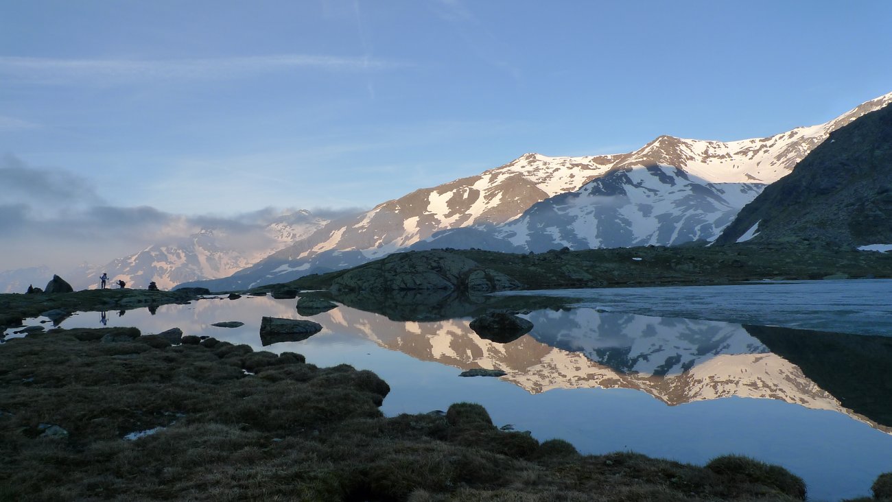
You follow a pleasant trail that winds past a series of glacial lakes before reaching the summit of Cima Collecchio. From the majestic summit cross, a stunning 360‑degree panorama opens up, stretching from the Val d’Ultimo below to Rifugio Dorigoni, with the nearby Sternai lakes shimmering at its side. Cima Collecchio lies right on the border between the South Tyrolean valley of Montechiesa and the Trentino region. After a scenic stretch along an easy ridge, the route skirts the slopes of the mountain and leads you to a wide, verdant basin crossed by lively streams, at the heart of the Val Saent. Dinner and overnight stay in hut.
- Day 4 - MARTELLTAL
Ascent: +690m. Descent: -860m. Altitude: 2260 - 2970m. Distance: 9km. Hiking time: 5h30.
Surrounded by a barren, rocky landscape, you ascend to Passo di Saent, a natural boundary that separates Val di Rabbi from Val Martello. From here, the descent into South Tyrol begins along well‑marked trails that drop down the opposite side toward the Plimabach stream, the main watercourse of Val Martello, fed by the glaciers of the Ortles‑Cevedale range. As you continue, the terrain gradually changes character, becoming softer and more gentle until you reach broad green pastures. Dinner and overnight stay in hut.
- Day 5 - FORCOLA GLACIER
Ascent: +775m. Descent: -430m. Altitude: 2260 - 3040m. Distance: 8km. Hiking time: 4h.
The itinerary leads to the crossing of the Forcola Glacier, where you will notice the signs of melting, especially over the steep final stretch just before Forcola Pass. Here you can admire the beautiful landscape with the best-known peaks of Ortler Cevedale. The descent on the opposite side of the mountains brings you back to the region of Trentino. The hike ends in today's hut, which is surrounded by a crown of peaks soaring over 3.500 meters: Cevedale, Zufall, Palon de la Mare and Vioz. Dinner and overnight stay in hut.
- Day 6 - CARESER GLACIER
Ascent: +520m. Descent: -685m. Altitude: 2430 - 3120m. Distance: 11km. Hiking time: 5h30, 1 hour walking over a small glacier.
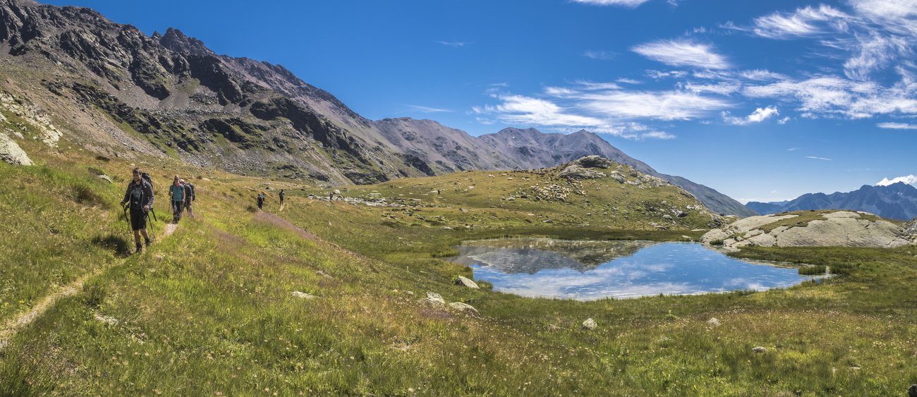
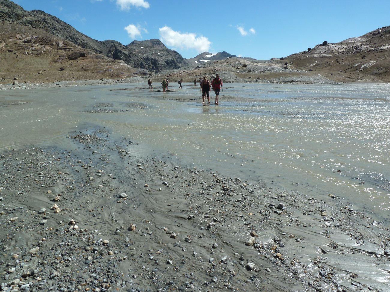
Today, you venture into a high‑altitude plateau dotted with numerous alpine lakes, eventually reaching the Careser Dam. With moderate gradients, you ascend through the barren, rocky terrain that surrounds you until you arrive at the final remnants of the Careser Glacier. The glacier’s meltwater feeds the lake of the same name, a key element in regional hydroelectric production. Crossing the glacier takes about one hour and can be completed along a simple and safe marked route. Once you reach the opposite side, a wide traverse on a gentle downhill slope leads you out of the glacial environment and back toward the grassy meadows of Val Saent. Dinner and overnight stay in hut.
- Day 7 - SAENT WATERFALLS
Ascent: +0m. Descent: -1180m. Altitude: 1350 - 2440m. Distance: 9km. Hiking time: 4h30.
Today you undertake a pleasant and panoramic descent, surrounded by agile marmots and rhododendron flowers. After the wide basin of Pra di Saent, the path leads you across the bridges and the splashing waters of Saent Waterfalls, the most important and scenographic waterfalls in Val di Sole. The alpine dairy, located almost at the end of the hike, is an excellent spot to taste local products. Last stretch on foot before going back to the hotel. Dinner and overnight stay in hotel.
- Day 8
After breakfast, check-out and departure.
Program details - 5 Day Tour:
This is the shorter variant of the tour and follows the first two legs of the main itinerary. After spending the night in the mountain hut located in the upper Val Saent, instead of continuing towards Val Martello, you begin the descent back to the starting point hiking through the Val Saent, passing by the waterfalls of the same name.
Program details - 6 Day Tour:
This variant does not include the crossing into Val Martello or the ascent to Passo della Forcola. On the fourth day, the tour takes you directly to Bocca di Saent, where the traverse across the Careser Glacier begins. The final stage leads you along Val de la Mare until you reach the village of Peio Paese.
Program details - 7 Day Tour:
The 7-day tour includes 5 days of hiking and follows the main itinerary up to Passo della Forcola. It does not include crossing the Careser Glacier, but instead descends along Val de la Mare to the village of Peio Paese.
Additional clarifications
The program could be changed at discretion of the Campo Base Team based on weather conditions and forecasts, mantaining however inalterate the basic structure and the aims of the proposal.
DATES & PRICES
SELF-GUIDED TOUR
| INDIVIDUAL PRICE | AVAILABILITY | ||
|---|---|---|---|
|
8 DAY TOUR
20.06.2026 - 20.09.2026 |
€ 875,00 | On request | |
|
8 DAY TOUR with MOUNTAIN HOTEL
20.06.2026 - 20.09.2026 |
€ 915,00 | On request | |
|
5 DAY TOUR
20.06.2026 - 20.09.2026 |
€ 535,00 | On request | |
|
6 DAY TOUR
20.06.2026 - 20.09.2026 |
€ 650,00 | On request | |
|
7 DAY TOUR
20.06.2026 - 20.09.2026 |
€ 750,00 | On request |
PRIVATE GUIDED TOUR
| INDIVIDUAL PRICE* | AVAILABILITY | ||
|---|---|---|---|
|
8 DAY TOUR
20.06.2026 - 20.09.2026 |
€ 1960,00 | On request | |
|
5 DAY TOUR
20.06.2026 - 20.09.2026 |
€ 1640,00 | On request | |
|
6 DAY TOUR
20.06.2026 - 20.09.2026 |
€ 1740,00 | On request | |
|
7 DAY TOUR
20.06.2026 - 20.09.2026 |
€ 1840,00 | On request |
* the price for the private guided tours is based on a minimum of 4 participants. You can set a larger or a smaller group – please contact us for a price.
Included services - SELF-GUIDED
- Accommodation in a 3-star hotel: 2 nights, double/triple room
- Accommodation in mountain huts: 2 - 5 nights depending on the itinerary, shared dormitory
- Half board basis
- Information file and hiking map
- 24-hour support
Excluded services - SELF-GUIDED
- Tourist tax in the lodging establishments where applicable
- Beverages and extra
- Single room supplement in hotel - € 60 in total
- Private room supplement at huts - € 10 per person per night - on request
- Rental of equipment (crampons) - € 15 + € 35 secutiry deposit
- Transfer by public bus - appx. € 10 per person
- Sleeping bag liner - on request € 18 or it can be rented/bought in the hut
- Traveler and cancellation's insurance
- Everything not mentioned
Included services - PRIVATE GUIDED
- Accommodation in a 3-star hotel: 2 nights, double/triple room
- Accommodation in mountain huts: 2 - 5 nights depending on the itinerary, shared dormitory
- Half board basis
- Local English-speaking mountain guide
- Transportation from the base camp hotel to the trailhead
- Transportation to the base camp hotel after the trek
- Rental of equipment (crampons)
- Information file and hiking map
- 24-hour support
Excluded services - PRIVATE GUIDED
- Tourist tax in the lodging establishments where applicable
- Beverages and extra
- Single room supplement in hotel - € 60 in total
- Private room supplement at huts - € 10 per person per night - on request
- Sleeping bag liner - on request € 18 or it can be rented/bought in the hut
- Traveler and cancellation's insurance
- Everything not mentioned
Booking, payment and cancellation conditions
USEFUL INFO
REQUIRED EQUIPMENT
Preparing for a hut-to-hut tour requires careful planning of equipment and clothing to best tackle the challenges of the route while ensuring comfort and safety during the hike. It is important to consider the variable conditions of mountain weather and the need to travel light yet fully equipped. Check out our Equipment List.
The travel documents we will send you will include a detailed list of the required equipment, specifically prepared for your itinerary. We kindly ask you to read it carefully and be well-prepared for the trekking journey.